|
|
Cold War Geodesy
|
|
|
Cold War Geodesy
|
NOTE: A large amount of these locations came from CLUI (https://clui.org/)
FEMA SitesNOTES: FEMA's “history” of parent agencies is roughly:
Many of the Regional Bunkers have changed their names (c.2020s) to “Regional Response Coordination Centers” (RRCCs). |
|||
|
Name |
Decimal Coordinates |
DMS Coordinates |
Notes |
|
Mount Weather Emergency Operations Center |
39.06338657, -77.8873641 |
39°03′48″N 77°53′15″W |
The underground portion (Area B) was built circa 1954-1959 by the Corps of Engineers at $1B cost and contains about 600,000 ft2 of space to support a population of 200 for 30~ days. FEMA's above ground portion (Area A) was constructed circa 1979. As of 2025, the formal name is the FEMA Operations Center (FOC) located at the Mt. Weather Emergency Operations Center (EOC). Other names associated with Mount Weather are:
|
|
FEMA National Emergency Training Center (1979-Present) |
39.695096, -77.326919 |
39°41′42″N 77°19′37″W |
Former college in Emmitsburg, MD that was purchased by the U.S. Government in 1979. |
|
FEMA Regional Bunker (Maynard, MA) |
42.411115, -71.448334 |
42°24′40″N 71°26′54″W |
FEMA Region 1 (CT, ME, MA, NH, RI, VY). |
|
FEMA Regional Bunker (New York) |
?? |
?? |
FEMA Region 2 (NJ, NY, Puerto Rico, US Virgin Islands) bunker. We know it may exist, but it's not publicly documented. |
|
FEMA Regional Bunker (Olney, MD) |
39.2093, -77.1063 |
39°12′33″N 77°06′23″W |
FEMA Region 3 (DC, DE, MD, PA, VA, WV). Near former NIKE Launch Area W-93. Has had a multitude of different names and jobs over its existence, such as: FEMA Alternate Operations Center (FAOC), etc. |
|
FEMA Regional Bunker (Thomasville, GA) |
30.805889, -83.988186 |
30°48′21″N 83°59′17″W |
FEMA Region 4 (AL, FL, GA, KY, MS, NC, SC, TN). |
|
FEMA Regional Bunker (Battle Creek, MI) |
42.327134, -85.188841 |
42°19′38″N 85°11′20″W |
FEMA Region 5 (IL, IN, MI, MN, OH, WI).Located inside the Hart-Dole-Inouye Federal Center's basement as a hardened EOC & comms center in the basement & sub-basement until the late 1990s, when FEMA moved out. |
|
FEMA Regional Bunker (Denton, TX) |
33.222132, -97.088448 |
33°13′20″N 97°05′18″W |
FEMA Region 6 (AR, LA, NM, OK, TX). Has two underground levels, with each around 25,000 square feet. Inside are communication facilities and, formerly, accommodations for up to five hundred people for 30 days. |
|
FEMA Regional Bunker (Kansas City) |
?? |
?? |
FEMA Region 7 (IA, KS, MO, NE) We know it may exist, but it's not publicly documented. |
|
FEMA Regional Bunker (Denver, CO) |
39.712959, -105.120465 |
39°42′47″N 105°07′14″W |
FEMA Region 8 (CO, MT, ND, SD, UT, WY) |
|
FEMA Regional Communications (Presidio, CA) |
37.801812, -122.458299 |
37°48′07″N 122°27′30″W |
FEMA Region 9 (AZ, CA, HI, NV, Pacific Islands). From 1982 to 2000 ish; FEMA renovated Barracks 105 at the Presido to place a “Communications Center” in the basement. It is unknown where FEMA was before that period. |
|
FEMA Regional Bunker (Santa Rosa, CA) and National Communications System Antenna Field |
38.411839, -122.753816 |
38°24′43″N 122°45′14″W |
(LINK). (LINK) “The former munitions magazine ("bomb dump") of Naval Auxiliary Air Station Santa Rosa was converted by the Federal Civil Preparedness Agency in the 1950s into a semi-hardened Federal Regional Center and communications facility. In the early 1970s, the Defense Civil Preparedness Agency established a regional office facility in two 1880s-era cavalry barracks (Bldg # 104 & 105, on Montgomery St) located on the Presidio of San Francisco -- a 'soft' facility, other than the semi-hardened communications & operations center in the the basement, which seemed to rely on this Santa Rosa facility as their HF radio annex in this era. In the late 1960s/early 1970s it was proposed that the OCD shut-down this Santa Rosa facility and build a brand-new, sophisticated hardened underground Federal Regional Center at the recently vacated Central Intelligence Agency Foreign Broadcast Information Service site a few miles away near Healdsburg. For what were probably budgetary and financial reasons, that was not done & this site remained in service.” The location is roughly approximate. |
|
FEMA Regional Bunker (Bothell, WA) |
47.789579, -122.236562 |
47°47′22″N 122°14′12″W |
FEMA Region 10 (AK, ID, OR, WA) |
|
National Communications System Antenna Field (Fort Custer, MI) |
42.327279, -85.342065 |
42° 19′ 38″ N 85° 20′ 31″ W |
(LINK). This antenna farm may have served the Region V EOC in the old days. |
Communications SitesBy the 1970s; AT&T's emergency plan consisted of the following three sites: National Emergency Control Center (Netcong, NJ) |
|||
|
Name |
Decimal Coordinates |
DMS Coordinates |
Notes |
|
Warrenton Training Center Site A |
38.703 799, -77.811161 |
38°42′11″N 799°00′00″E |
This portion of WTC is mainly for training. It is used as a training center for a variety of federal agencies, including the Department of State and the CIA. |
|
Warrenton Training Center Site B |
38.734200, -77.830004 |
38°44′03″N 77°49′48″W |
Headquarters annex for Warrenton Training Center [WTC] |
|
Warrenton Training Center Site C |
38.519501, -77.785169 |
38°31′10″N 77°47′07″W |
Antenna facility. WTC is on the LSI fiber optic network and was part of the National Communications System. |
|
Warrenton Training Center Site D |
38.459932, -77.851167 |
38°27′36″N 77°51′04″W |
Antenna facility. WTC is on the LSI fiber optic network and was part of the National Communications System. |
|
Tyson's Corner AT&T Long Lines Tower |
38.920295, -77.229859 |
38°55′13″N 77°13′47″W |
Microwave tower that linked the Pentagon into the AT&T Longlines system. |
|
AT&T “Project Office” Bunker (HAG2) |
39.712053, -77.972964 |
39°42′43″N 77°58′23″W |
The HAG2 Site is equipped with tropospheric scatter antennas on top of a hardened nuclear bunker which housed the communications equipment. Due to the heavy presence of Continuity of Government facilities, including Site C and Raven Rock, HAG2 served as an auxiliary link for them. In addition to serving as an auxiliary relay station, HAG2 was the northernmost station that connected to the Long Lines in the Northern United States. |
|
AT&T “Project Office” Bunker (Big Hole) |
35.782778, -79.074167 |
35°46′58″N 79°04′27″W |
The BIG HOLE Site is equipped with tropospheric scatter antennas on top of a hardened nuclear bunker which housed the communications equipment. |
|
AT&T “Project Office” Bunker (Peters Mountain) |
38.125833, -78.286111 |
38°07′33″N 78°17′10″W |
|
|
AT&T “Project Office” Bunker (Short Hill Mountain) |
39.266667, -77.707222 |
39°16′00″N 77°42′26″W |
|
|
AT&T “33 Thomas Street” Switching Center |
40.71648, -74.006063 |
40°42′59″N 74°00′22″W |
33 Thomas Street in Manhattan is a 550 foot tall telephone switching center, the largest in the city, and among the largest in the world. It was built by AT&T in 1974, as its new Long Lines (long-distance) hub. |
|
AT&T “10th Avenue” Central Office |
40.767149, -73.990806 |
40°46′02″N 73°59′27″W |
811 10th Avenue is a “modern”, windowless AT&T Central Office (CO) telecommunications building, that housed microwave links and switching equipment. The 40-story building was the largest Central Office (CO) in Manhattan at the time. |
|
AT&T “Netcong” Bunker |
40.865439, -74.679222 |
40°51′56″N 74°40′45″W |
For more than a decade, this was the principal network operations center for AT&T. It is located on a hilltop in Netcong, New Jersey, not too far from the company’s later control center and headquarters in Bedminister and Basking Ridge. The Netcong center is in a 86,000 square foot, two level subterranean building, with walls of concrete more than 2 feet thick, and entirely cased in steel. Communications lines once branched out from here all over the land, and through microwave links in the tower. The facility included accommodations and supplies for the 30 people who operated the center to live underground for up to three weeks. |
|
AT&T Fairview, KS Bunker |
39.758747, -95.733007 |
39°45′31″N 95°43′59″W |
Co-Located with AUTOVON hardware. |
|
AT&T Rockdale (Conyers, GA) Bunker |
33.627776, -83.979028 |
33°37′40″N 83°58′45″W |
|
|
Hawes Radio Relay Site, March AFB Detachment (SAC Giant Talk 46) |
34.917547, -117.376885 |
34°55′03″N 117°22′37″W |
From the 1960's to the 1980's the site was part of the military's SLFCS and GWEN emergency communication networks, used for low frequency communications by the Strategic Air Command. Equipment included a 1,226 foot tall tower, and a two level underground bunker full of power and communications equipment. When the tower was torn down in the mid 1980's, the lower half of the tower fell sideways and the top half of the tower collapsed onto the bunker. Until recently, portions of the top half of the tower could be seen protruding from the roof of the bunker. The tower and the equipment were scrapped, and the underground bunker was left open and exposed to scavengers. It became a party spot, covered in graffiti, until 2008, when two local teenagers were murdered after attending a party there. The Air Force and the BLM demolished the remains, and filled in the underground parts. |
|
Barksdale Communications Annex (SAC Giant Talk 46) |
|
|
“This facility was phased out as the USAF proved that AFSATCOM was a more effective communications medium during Project ELF One. Quasi decommissions in 81 and 82 (Top Secret Gear ripped out), and then used for 2-3 years after that for Secret and Confidential materials, and then fully retired and the antennas taken down.” |
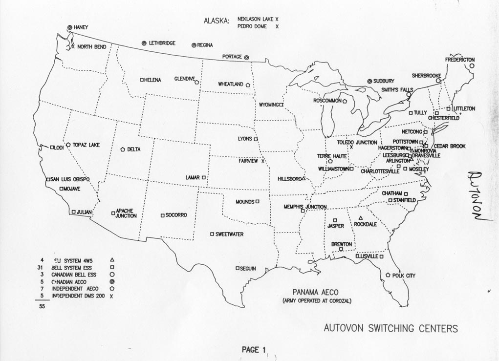
AUTOVON SitesA lot of information is contained within the Long-Lines Website (LINK) as well as this mid-1970s AUTOVON system map. |
|||
|
Name |
Decimal Coordinates |
DMS Coordinates |
Notes |
|
AT&T AUTOVON Tower (Mounds, OK) |
35.830892, -96.145712 |
35°49′51″N 96°08′45″W |
|
|
AT&T AUTOVON Tower (Lyons, NE) |
42.00483322, -96.41397095 |
42°00′17″N 96°24′50″W |
|
|
AT&T AUTOVON Tower (Weatland, ND) |
46.8982964038059, -97.3469659983348 |
46°53′54″N 97°20′49″W |
|
|
AT&T AUTOVON Tower (Glendive, MT) |
47.1202774, -104.4786148 |
47°07′13″N 104°28′43″W |
|
|
AT&T AUTOVON Tower (Boone, IA) |
42.165219, -93.794171 |
42°09′55″N 93°47′39″W |
“On the surface is a microwave relay tower, built as part of AT&T’s nationwide communications system in the 1960s. The bunker here, with around 20,000 square feet, was larger than a typical relay station, as it housed equipment for the AUTOVON system, which was a military communications network that existed independently of AT&T’s civilian network. Additional security included thicker walls, more space, bigger blast doors, and spring loading for equipment rooms.” |
|
AT&T AUTOVON Tower (Fairview, KS) |
39.758747, -95.733007 |
39°45′31″N 95°43′59″W |
“An AT&T Long Lines site, one of hundreds that were part of its long distance network, using microwave transmission. This site is a bit unusual, as it was also one of a few dozen AT&T transmission sites that were part of the AUTOVON, a military communications system. This site, in Fairview, may have been especially critical as it provided a connection point to the national Long Lines and AUTOVON system with Offutt Air Force Base, 90 miles north. There is an underground bunker here.” |
|
Name |
Decimal Coordinates |
DMS Coordinates |
Notes |
|
District of Columbia Civil Defense Emergency Operations Center |
38.686411, -77.242956 |
38°41′11″N 77°14′35″W |
Located somewhere within the Youth Center Complex (aka Prison) run by the DC government at Lorton, VA. Location is very imprecise! |
|
Office of Censorship Bunker |
39.582719, -77.002821 |
39°34′58″N 77°00′10″W |
“A now unoccupied bunker below the basement of the Lewis Hall of Science at Western Maryland College is an interesting case in point. This 6,000 square foot chamber, accessed by elevator, and equipped with a broadcast facility connected to FEMA’s communications infrastructure, was for the leaders of the United State Office of Censorship, later renamed the Wartime Information Security Program. In the event of a war, a group of eight appointed individuals, and a staff of 40, were to convene at this location to assume their duties leading the national censorship of news broadcast and print media, according to federally mandated emergency guidelines, listed in manuals and code books stored in the bunker. One of the directors of this program was the Vice-President of CBS.” |
|
Harpers' Ferry Bunker |
39.324400, -77.741275 |
39°19′28″N 77°44′29″W |
A bomb shelter is located under the lawn north of the National Park Service's Stephen P. Mather Training Center, formerly Storer College, off Fillmore Street in Harper's Ferry, WV. The history of the shelter is still being investigated, but available information indicates that it was an emergency relocation site for Department of the Interior headquarters and the Secretary of the Interior. |
|
Name |
Decimal Coordinates |
DMS Coordinates |
Notes |
|
Presidential Emergency Operations Center (PEOC) |
38.89758, -77.03567 |
38°53′51″N 77°02′08″W |
Under White House East Wing. (Approx.) |
|
Raven Rock Mountain Complex (RRMC) [Site R] |
39.738814, -77.413301 |
39°44′20″N 77°24′48″W |
|
|
Project Casper / Project Greek Island |
37.78451, -80.30908 |
37°47′04″N 80°18′33″W |
Congressional Bunker. AKA “Greenbrier Bunker” |
|
National Military Command Center (NMCC) [Site M] |
38.87097, -77.05595 |
38°52′15″N 77°03′21″W |
Underneath Pentagon in Joint Staff Area. Coordinates are for “Cafe Ground Zero” in Courtyard. |
|
Cheyenne Mountain Complex |
38.74311, -104.84811 |
38°44′35″N 104°50′53″W |
|
|
Camp David (TALL-TOP) |
39.648165, -77.465184 |
39°38′53″N 77°27′55″W |
Unconfirmed rumors about more extensive bunkers at Camp David besides a simple 1959 Bomb Shelter persist, including rumors of a tunnel connecting it to Site R – Raven Rock. |
|
Name |
Decimal Coordinates |
DMS Coordinates |
Notes |
|
Mount Pony |
38.442044, -77.973226 |
38°26′31″N 77°58′24″W |
Used 1969-1992 by Treasury and Federal Reserve. Until 1998, $1B in $2 dollar bills stored on site for reconstruction. Also was principal hub of Federal Reserve secure communications system. |
|
Defense Industrial Plant Equipment Facility (Atchinson, KS) |
39.536871, -95.113734 |
39°32′13″N 95°06′49″W |
987,000 ft2 of underground space in a converted limestone mine holding thousands of machine tools and industrial tooling for post-attack reconstruction. |